 |
| Harbour Grace, indicated with the red star, is located on the Avalon Peninsula in southeastern Newfoundland. (Image courtesy Mapquest.com) |
LOCATION
 |
| Harbour Grace, indicated with the red star, is located on the Avalon Peninsula in southeastern Newfoundland. (Image courtesy Mapquest.com) |
HISTORY and BACKGROUNDThese excerpts, borrowed from the Harbour Grace web page, focus on the aeronautical history of the town.
"Harbour Grace, founded by Francis I of France in 1517, is thought to have derived its name as an adaptation of Le Havre-de-Grâce, which is the name of the sea port town at the mouth of the River Seine in France. The town eventually established itself as a fishing community. By the turn of the 20th century, the town's prosperity continued to decline. Adding to the problems was the opening of the iron mines on Bell Island which saw approximately 200 men give up the fishery in favour of a more stable income. The town's 1921 census which showed a population of 2,661 inhabitants, was down from 5,184 in 1901. Shipbuilding was extensive in Harbour Grace during the second decade of the 1900's and during the winter months, ships were refitted and repaired. However, the area's fishery was still poor. By 1935 the population had once again dropped, now totalling 2,215.
The Harbour Grace airstrip was one of the town's newsmakers. In 1927, Fred Koehler, a representative of the Stenson Aircraft Corporation of Detroit, was in Newfoundland looking for a suitable location for a hopping off place for an around the world flight. He selected Harbour Grace as the best location for such a site and on August 8th work began on the project. Using horses and carts, along with some machinery supplied by the government, workers cleared the area of bushes, large stones and rocks. Just weeks later, on August 27th, the Harbour Grace Airstrip was complete. Measuring 4000 feet long and 200 feet wide, it consisted of a smooth gravel surface which was completely flat except for a 4% decline on one third of the field. This decline was later found to be of great assistance to aircraft taking off with heavy loads. On the east end of the field was a low bluff which acted as a landmark for inbound pilots. At the time of its construction, it was the first civilian airport in North America to be built for transatlantic flying. Even prior to the establishment of an actual airport, the town was chosen to be the starting point for many attempts to cross the Atlantic. Most of these attempts were unsuccessful.
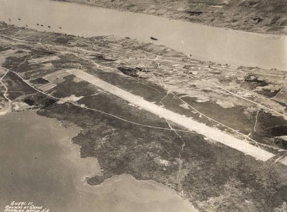 |
| The runway at Grace Harbor looking northeast, May 1932. It is located
at 47° 41' 8.50" N
53° 15' 9.83" W. (Photo #b10F2il courtesy Perdue University) |
Of those who took to the skies from the airstrip, one of the most celebrated figures was Amelia Earhart. She was the third person and the first woman to cross the Atlantic solo. At 7:20 p.m. on May 20th, 1932, Earhart climbed aboard her Lockheed Vega and used the Harbour Grace airstrip as the starting point for another flight into the history books. Approximately 15 hours after take off, despite having encountered a storm, fog, and a malfunction which caused flames to shoot from her exhaust, she reached Londonderry, Northern Ireland.By the end of 1936, the fame and glory associated with flying the Atlantic were fading fast. As a result of this, Jimmy Mollison's flight was the last time the Harbour Grace airstrip was used as a final take off point from North America. The Harbour Grace airport served early aviators for nine years. Of the 20 flights which were attempted from Harbour Grace, there were eleven successful, four unaccounted for, two crashed on take off, two were aborted for undisclosed reasons, and one crash landed off the coast of Ireland.
During World War II, the Royal Canadian Navy established and operated a High Frequency Direction Finding station on the airfield. Harbour Grace was one of the first sites that the Royal Canadian Navy was solely responsible for and DOT had no involvement with this particular site. The site served as the perfect location for such an operation and throughout the war the station intercepted countless enemy messages and provided valuable intelligence data.
Following the war, the airstrip was left to deteriorate. In 1977, through the efforts of the Harbour Grace Historical Society, it was restored to usable condition. In 1999, after years of being considered abandoned, the airstrip was reinstated to official international airdrome status under the designator of CHG2 "
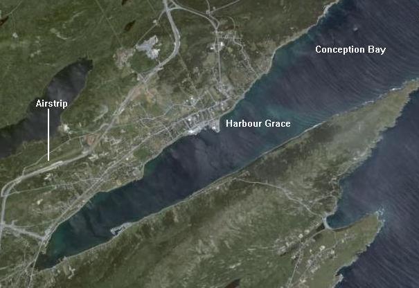 |
| This 2007 map shows Harbour Grace and general vicinity. North is the top of the image (Image courtesy Google Earth) |
 |
| Close-up of the airstrip. (Image courtesy Google Earth) |
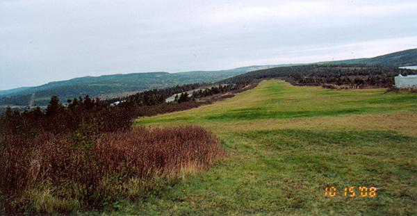 |
| Ground view of the runway. |
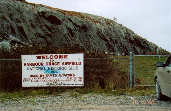 |
| The runway has been declared a National Historic Site as attested by this sign. |
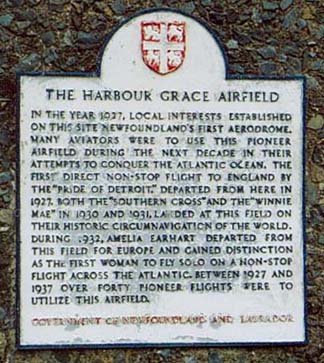 |
| The plaque at the airstrip is mounted on a cairn. |
THE STATIONIn July 1941, the Harbour Grace Special Wireless Telegraphy Station became operational [1]. Consisting of an Operations Building and a DF shack, the station had an uninterrupted sweep of the northern Atlantic sector and was able to provide bearings on U-boat transmissions and also intercepting enemy traffic. Visitors to the site painted a picture of the poor conditions that were that faced by the station's operators. In the book "History of Canadian Signals Intelligence and Direction Finding" it cites these extracts from visitor's reports:
"The station is much too small for the number of people it is expected to accommodate. Ventilation is extremely poor and sanitation non existent. The developing of films [2] is made extremely difficult by the lack of water, the nearest supply being a well about 200 yards, from the station.Ted Vlachos V-54941, served as a Telegraphist at Harbour Grace from 1942 to 1945. He confirms the above conditions but also underscores that conditions improved somewhat over the course of the War. Ted also confirms the use of the National HRO receiver at the station but doesn't recall the type of D/F sets which were in use.Living conditions are cramped at the W/T station and lack of sanitary accommodation and running water is most unhealthy.
While most of our men look healthy enough, it was learned that living conditions in many cases were deplorable. Having only a limited amount to spend on lodgings, the men are often obliged to seek out the cheaper homes, where both rooms and food are of a very poor quality".
He also recalls a close brush with fate relating to his posting. "After joining the navy at HMCS Star in Hamilton in 1942, I was eventually transferred to Naval Headquarters in Ottawa where I received D/F and intercept training. Because of a two week delay in my course, that also delayed my deployment to Harbour Grace by the same amount of time. It was to be my lucky day for the ship transporting personnel to points on the East Coast and including Harbour Grace was torpedoed with the loss of 132 lives. In 1946, Ted received the British Empire Medal for his recognition as a keen and conscientious operator whose hard work improved the station's efficiency and served as an example for far less experienced operators."
Ken Macpherson, co author of The Ship's of Canada's Naval Forces, served at Harbour Grace in 1944-45. He confirms that the W/T station was located right on the airstrip, in two buildings. One building was Operations Intercept where the operators stood their watches. The other being further away, was the DF building. (This would also suggest that the airfield was closed to any aviation traffic after the W/T station was established). Once a bearing was obtained on a target of interest, it was circulated to the network by teletype. Art Clare, a Saskatoon native, was one of the teletype operators.
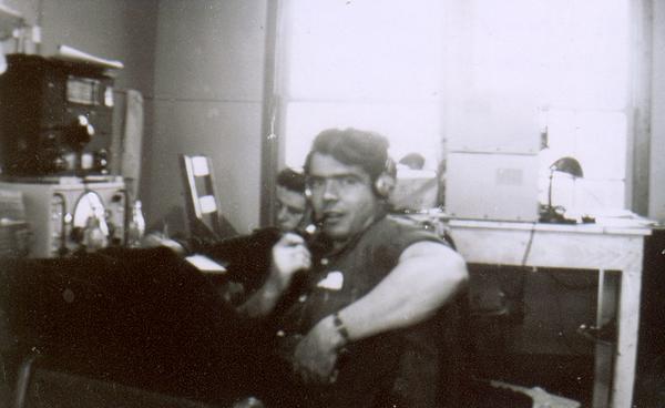 |
| Harbour Grace Operations Room. In the foreground is RCNVR Don Hickey (Tel. S.O) from British Columbia. In the background is Tel. S.O. Rand from Belleville , Ontario (?) , He is either intercepting signals with a Canadian Marconi CSR-5 receiver with an HRO receiver above it. In the background and sitting on the table are two Marconi CSR5 receivers. They are stacked and facing opposite directions. In front of each is a gooseneck lamp, a dead giveaway that an operator sits here. (Photographer unknown) |
Vin Crane, who served at Special Wireless Station Coverdale, says that there was a continuous contest going with the D/F station at Harbour Grace to see who could submit their bearings first.Joe Costello, RC Sigs web page, describes the station's watches.
"A watch consisted of eight ratings; six of which were on intercept, an experienced Telegraphist on the D/F set and a Leading Telegraphist in charge. In charge, of the station was a Chief Petty Officer. The personnel were divided into four 8-hour watches, rotating on a two-day basis, allowing a forty-eight-hour lay-off every eight days. Their lodgings were provided by private homes and boarding houses in the town itself; some three miles from the base. A station wagon with a civilian operator, shuttled personnel back and forth at shift changes".
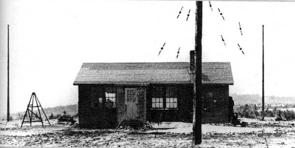 |
| The DF shack at Harbour Grace in 1945. Assuming the door width is the
standard 30 inches, then the shack is 26.75 feet wide and 12.5 feet to
the peak of the roof. (Photo from the Ken Macpherson collection and
Canadian Warship Names by David Freeman. Used with permission)
Each intercept operator had a microphone and upon hearing a U-boat transmission, they would call the D/F Operator who sat surrounded by sets tuned to their various frequencies of interest and thus obtaining a bearing on the U-boat instantly. The reports were transmitted back to the network by a Teletype operator. |
TINA/RFP equipment ('Z' intelligence) was given to the RCN by the British Admiralty in December 1941 and by January 1942, operations on an experimental basis had begun at a Department of Transport station near Ottawa. In May 1943, "Z" operations moved to the RCN station at Gloucester Ontario but due to the drop in U-boat W/T traffic, the RCN chose to install RFP/TINA at Harbour Grace, Newfoundland.
CLOSUREOn May 21/45, the Canadian Naval Service approved the closing down and disposal of its facility at Harbour Grace. The station's assets were likely disposed of by 1946.
FOOTNOTES
[1] From "A Nationís Navy" by Michael L. Hadley
[2] The mention of film developing might suggest some 'Z' intelligence activity at this station.QUESTION:
1) Does anyone know the approximate location of the special wireless station relative to the airstrip?
Contact : jerry.proc@sympatico.ca
Credits and References:1) Joe Costello. http://www.rcsigs.ca/ViewPage/History/Canadian-CESM-History/Page/2
2) "The Canadian History of Signal Intelligence and Direction Finding" by Robert Lynn Wortman and George T. Fraser
3) Harbour Grace History http://www.hrgrace.ca/history.html
4) Ted Vlachos, RCNVR, Niagara Falls, Ont.
5) Perdue University E-archives http://e-archives.lib.purdue.edu/
6) Vin Crane WREN <cravin(at)shaw.ca>
7) Ken Macpherson <kmacpherson12(at)cogeco.ca>
8) Don Cameron papers. Part 4
9) http://www.rcsigs.ca/index.php/History_of_Canadian_CESM
MAr 11/22