 |
This topographical map of CFS Leitrim is
dated 1970 but shows information dated as 1968. In evidence are the three
rhombic arrays plus the CDAA site that was started but never constructed.
(Map
image from the collection of Bill Robinson) |
 |
This is a general view of the Leitrim property
taken on May 11, 1970 from an altitude of 2,500 feet. North is approximately
at the 11 o'clock position. The Pusher antenna has not been built yet but
it shows up in photo A23612-12 dated September 1973. Its construction can
therefore be narrowed to the 1970-1973 time frame. The rectangular building
with the dark grey roof is the new operations building built in 1968 for
about $500,000. (National Air Photo Library photo # A22250-32) |
 |
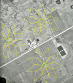
This is a rendering of the three rhombic arrays
on the property. Unfortunately the third array could not be rendered since
it was not possible to locate a photo which spanned the necessary distance.
In April 1972, the rhombics and the GRD-6 at Leitrim were to be dismantled
following the evaluation and acceptance of the PUSHER system
(National
Air Photo Library photo # A22250-32) |